Cyclone Gabrielle set for 'one final sting' over New Zealand's South Island as record storm leaves trail of devastation
15 February 2023
Cyclone Gabrielle is set to have one final sting in its tail before the weather improves across the parts of New Zealand battered by phenomenal surging waves, persistent hammering rain and storm force winds.
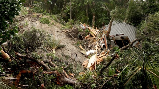
The reach and the wrath of Cyclone Gabrielle has been extensive, with the violent weather system considered to be the most severe the country has experienced this century and one of the strongest ever to hit the North Island.
On Sunday, the cyclone moved south of Norfolk Island and over cooler subtropical waters.
This is known as extratropical transition – a revolving storm that still exists but takes on the characteristics of a midlatitude cyclone (like an east coast low).
It is a vast understatement to refer to this system as the "remnants of", or an "ex tropical cyclone".
Gabrielle was, and remains a deep, violent weather system, and the numbers back this up.
#CycloneGabrielle has brought a wild 24hrs of weather around the North Island and impacts will continue today.
Rain also spreads into northeastern parts of the South Island with south/southeast gales across the northern half.
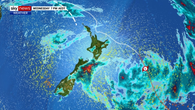
The New Zealand weather authority MetService assessed Gabrielle’s centre pressure at noon on Tuesday at an ear-popping 965 hectopascals, and the reach of gale force winds – a measure of cyclone size, extended beyond the east coast of the North Island.
Cloud extended as far south as Christchurch as the system dipped toward the Coromandel Peninsula and then ran across the top of the Bay of Plenty.
Rain totals and wind readings painted a picture of the widespread devastation:
- Northland was hit first and for the longest period. Cape Reinga reported 30 consecutive hours of gale-force winds (over 34 knots, or 68km/h).
- The most populated city, Auckland, collected over 200mm of rain in 24 hours. Gusts between 90 and 110km/h battered the city for hours on Monday and Tuesday.
- Auckland registered a Mean Sea Level Pressure of 972hPa
- 400mm of rain feel across the Gisborne region in 36 hours – more than Perth would usually see in a whole winter.
- Destructive wind gusts of over 150km/h hit many places.
- Napier recorded 175.8mm of rain on Monday – the second wettest day on record for the city.
- Twenty weather warnings were in place on Monday and Tuesday – the highest on record, as a National state of emergency was declared for only the third time in history.
On Wednesday, Gabrielle’s reach will extend to the South Island as the cyclone continues to push east.
Heavy southerly winds in the wake of Gabrielle will drive heavy rain across the eastern Marlborough and Canterbury region of the South Island, with 100-150mm expected to fall in the next 24 hours.
The southernmost tip of the North Island – east of the capital Wellington, remains on alert for flash flooding as well.
Strong winds will whip Wellington and the east coast of the North island until mid-Friday.
A calm weekend then awaits the entire nation under a high pressure system.